Anzu Raptor w/ RTK Module & Charging Hub + 1-Year Care Protection
Anzu Raptor w/ RTK Module & Charging Hub + 1-Year Care Protection
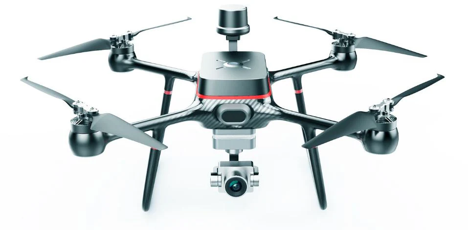
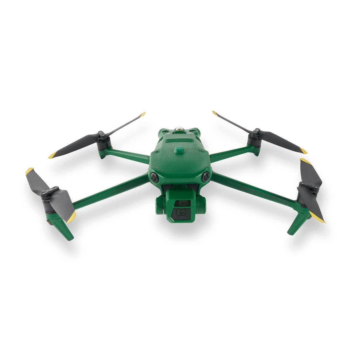
Anzu Raptor is a cutting-edge drone solution crafted to meet the precise demands of industry professionals. Designed and manufactured in the United States, it prioritizes national security, data privacy, and exceptional performance.
Backed by advanced imaging capabilities, unparalleled flight endurance, and seamless operational flexibility, the Anzu Raptor empowers users to excel in specialized fields such as agriculture, search and rescue, and infrastructure inspection.
Precision, Power, and Security
Unrivaled Imaging Technology
-
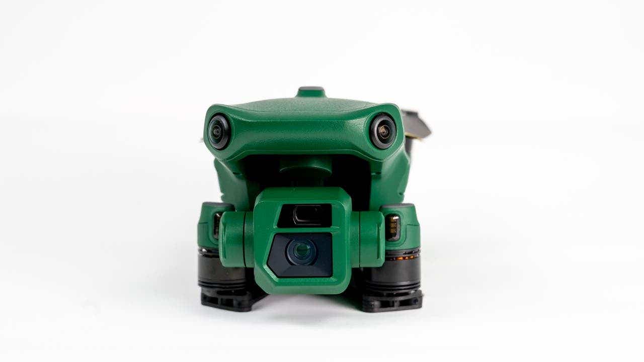
High-Resolution Visuals: The Anzu Raptor is equipped with a 48MP primary camera, capturing sharp, detailed images to meet the highest professional standards.
-
56x Hybrid Zoom: Enables precise imaging from significant distances, perfect for inspections and surveillance.
This state-of-the-art imaging system ensures that professionals can collect critical data with accuracy and confidence.
Endurance and Efficiency
-
Extended Flight Time: Operates for up to 45 minutes on a single charge, allowing you to cover extensive areas with fewer interruptions.
-
Long Range: With a range of 9 miles, the drone is ideal for expansive missions, from mapping projects to large-scale inspections.
The Anzu Raptor’s focus on flight endurance reduces downtime and enhances overall productivity.
Enhanced Navigation with RTK
-
Centimeter-Level Accuracy: The Real-Time Kinematic (RTK) module provides exceptional precision for complex applications.
-
Reliable Navigation: Ideal for demanding environments where precision is critical, such as industrial inspections and resource mapping.
Seamless Integration with Professional Tools
-
Third-Party Compatibility: Works with leading platforms like DroneDeploy and DroneLink, enabling automated mapping and tailored workflows.
The Anzu Raptor’s adaptability ensures it integrates effortlessly into existing professional ecosystems, offering a versatile and efficient solution for your needs.
Security and Compliance You Can Trust
-
Data Privacy: All data is stored securely on U.S.-based servers, addressing concerns about foreign-manufactured technology.
-
FAA Compliance: Includes pre-flight checklists and quick LAANC authorizations, ensuring safe, responsible operation within the National Airspace System.
These robust safety and security features give professionals peace of mind and the assurance of compliant, reliable performance.
Revolutionizing Industries
Public Safety and Emergency Response
-
Search and Rescue Missions: Detect and locate missing persons with advanced imaging and thermal capabilities.
-
Firefighting Operations: Identify hotspots and assist with real-time situational analysis.
-
Law Enforcement: Conduct discreet surveillance and gather critical data for investigations.
Agriculture and Environmental Monitoring
-
Monitor crop health, optimize irrigation, and detect pests or diseases with precision imaging.
-
Survey wildlife habitats and track environmental changes without disrupting ecosystems.
Infrastructure and Industrial Inspections
-
Assess powerlines, pipelines, and other infrastructure for maintenance needs or potential hazards.
-
Inspect buildings, bridges, and other structures with high-resolution visuals and accurate data.
Mapping and Surveying
-
Generate detailed maps for urban planning, construction, and resource management.
-
Conduct aerial surveys with RTK-enabled precision for accurate results.
Whether addressing public safety challenges, enhancing agricultural efficiency, or performing critical infrastructure inspections, the Anzu Raptor adapts to meet the specific demands of each industry.
Specifications:
Performance
- Maximum Horizontal Speed: 47 mph / 75.6 km/h
- Maximum Ascent Speed: 17.9 mph / 28.8 km/h
- Maximum Descent Speed: 13.4 mph / 21.6 km/h
- Maximum Wind Resistance: 26.8 mph / 43.1 km/h
- Maximum Take-Off Altitude: 3.7 miles / 6 km
- Maximum Flight Time: 45 minutes
- Maximum Hover Time: 38 minutes
- Maximum Tilt Angle: 35°
-
Hovering Accuracy:
Vision Positioning:
Vertical: ±0.3' / 0.1 m
Horizontal: ±1.0' / 0.3 m
GNSS:
Vertical: ±1.6' / 0.5 m
High-Precision Positioning System:
Horizontal: ±1.6' / 0.5 m
- Maximum Angular Velocity: 200°/s
Aircraft
- Rotor Configuration: Quadcopter
- Propeller Size: 9.4x5.3"
- Remote ID: Yes
- Built-In Video Light: No
- Aircraft I/O: 1x USB-C (Service)
- Operating Temperature: 14 to 104°F / -10 to 40°C
Imaging
- Number of Cameras: 3
-
Camera System:
Thermal: Vanadium Oxide (VOX) Sensor with -4 to 932°F / -20 to 500°C Measurement Range (61° FoV)
-
Digital Zoom:
Thermal: 28x
Telephoto: 8 to 56x
-
Minimum Focus Distance:
Thermal: 16.4' / 5 m
Wide: 3.3' / 1 m
Telephoto: 9.8' / 3 m
-
ISO Sensitivity Range:
Wide: 100 to 25,600
Telephoto: 100 to 25,600
-
Shutter Speed:
Wide: 1/8000 to 8 seconds (Photo/Video)
Telephoto: 1/8000 to 8 seconds (Photo/Video)
-
Maximum Video Resolution:
Thermal: Up to 512p at 30 fps
Wide: Up to UHD 4K at 30 fps
Telephoto: Up to UHD 4K at 30 fps
-
Still Image Support:
Wide: Up to 48 MP (JPEG)
Telephoto: Up to 12 MP (JPEG)
- Photo Modes: Interval, Single Shot
-
Media/Memory Card Slot:
In Aircraft Body: microSD/microSDHC/microSDXC (UHS-I) [512 GB Maximum / U3/V30 or Faster Recommended]
In Remote/Transmitter: microSD/microSDHC/microSDXC (UHS-I) [U3/V30 or Faster Recommended]
-
Internal Storage:
In Remote/Transmitter: 8 GB
Gimbal
- Number of Axes: 3 (Pitch, Roll, Yaw)
-
Rotation Range:
Mechanical Range:
Yaw (Pan): 54° (-27 to 27°)
Pitch (Tilt): 180° (-135 to 45°)
Roll: 90° (-45 to 45°)
-
Follow Speed:
Tilt: 100°/s
- Stabilization Accuracy: ±0.007°
Avoidance/Sensing System
- Sensing System: Omnidirectional
-
Sensing System Capabilities:
Forward:
Measurement Range: 1.6 to 65.6' / 0.5 to 20 m
Detection Range: 1.6 to 656.2' / 0.5 to 200 m
Max Speed: 33.6 mph / 15 m/s
Field of View: 90° (Horizontal) / 103° (Vertical)
Backward:
Measurement Range: 1.6 to 52.5' / 0.5 to 16 m
Max Speed: 26.8 mph / 12 m/s
Field of View: 90° (Horizontal) / 103° (Vertical)
Lateral:
Measurement Range: 1.6 to 82.0' / 0.5 to 25 m
Max Speed: 33.6 mph / 15 m/s
Field of View: 90° (Horizontal) / 85° (Vertical)
Upward:
Measurement Range: 0.7 to 32.8' / 0.2 to 10 m
Max Speed: 13.4 mph / 6 m/s
Field of View: 100° (Front-to-Back) / 90° (Side-to-Side)
Downward:
Measurement Range: 1.0 to 59.1' / 0.3 to 18 m
Max Speed: 13.4 mph / 6 m/s
Field of View: 130° (Front-to-Back) / 160° (Side-to-Side)
Remote Controller / Transmitter
- Control Method: Included Transmitter
-
Operating Frequency:
2.4 GHz (2.400 to 2.484)
5.8 GHz (5.725 to 5.850)
- Maximum Operating Distance: 9.3 miles / 15 km
-
Transmitter Power:
2.4 G: 33 dBm (FCC), 20 dBm (CE, MIC, SRRC)
5.8 G: 33 dBm (FCC), 23 dBm (SRRC), 14 dBm (CE)
-
Transmitter I/O:
1x USB-C (Data, Power)
1x Mini-HDMI (Video)
- Clean Video Output: No
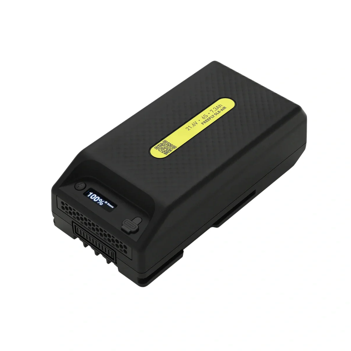
- Battery Type: Built-In Lithium-Ion (5000 mAh)
- Wi-Fi: Wi-Fi 6 (802.11ax); Tri-Band (2.4, 5, & 6 GHz) with MU-MIMO Support (2 x 2)
- Bluetooth: 5.1
- Mobile App Compatible: No
- Built-In Display: 5.5" (1920 x 1080) Touchscreen LCD, 1000 nits/cd/m²
- Operating Temperature: 14 to 104°F / -10 to 40°C
Flight Battery
- Battery Chemistry: Lithium-Ion Polymer (LiPo)
- Battery Capacity: 5000 mAh / 77 Wh
- Battery Configuration: 4 S / 15.4 V
- Maximum Charging Power: 17.6 V
- Charging Temperature: 41 to 104°F / 5 to 40°C
- Weight: 11.8 oz / 335.5 g
Charger
- Charger Input Power: 100 to 240 VAC, 50/60 Hz at 2.5 A
- Power Rating: 100 W
General
- GNSS Support: GPS, GLONASS, BeiDou, Galileo
- Diagonal Size: 15" / 380.1 mm
-
Overall Dimensions:
Folded: 3.8 x 3.6 x 8.7" / 96.3 x 90.3 x 221.0 mm
Unfolded: 11.1 x 4.2 x 13.7" / 283.0 x 107.7 x 347.5 mm
-
Weight:
With Propellers: 2.0 lb / 920 g
Maximum for Takeoff: 2.3 lb / 1050 g
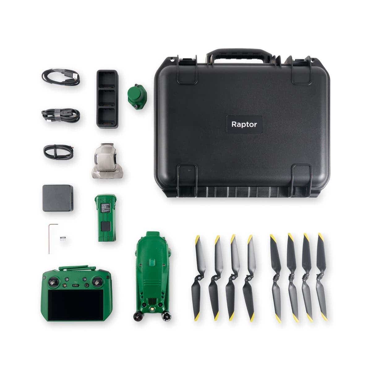
What's in the Box:
1 x Anzu Raptor aircraft
1 x Controller w/ built-in screen
1 x Battery
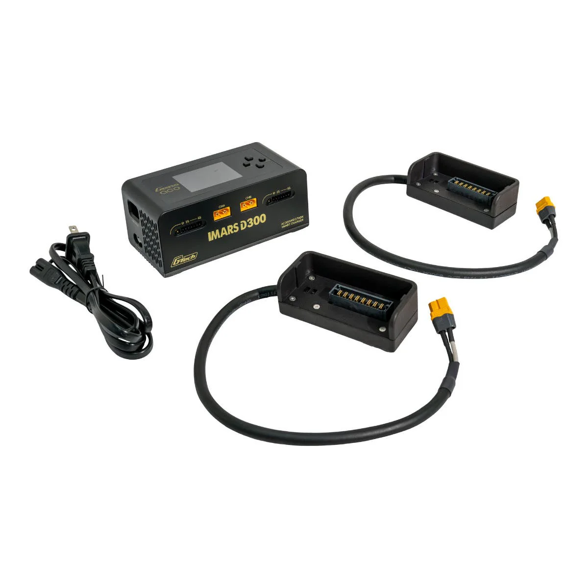
1 x Charging Station
1 x RTK Module
1 x Charging Hub
1 x Set Propellers
1 x Hard Case
Manuals
More Images


Anzu Raptor w/ RTK Module & Charging Hub + 1-Year Care Protection
Anzu Raptor w/ RTK Module & Charging Hub + 1-Year Care Protection
Anzu Raptor is a cutting-edge drone solution crafted to meet the precise demands of industry professionals. Designed and manufactured in the United States, it prioritizes national security, data privacy, and exceptional performance.
Backed by advanced imaging capabilities, unparalleled flight endurance, and seamless operational flexibility, the Anzu Raptor empowers users to excel in specialized fields such as agriculture, search and rescue, and infrastructure inspection.
Precision, Power, and Security
Unrivaled Imaging Technology
-
High-Resolution Visuals: The Anzu Raptor is equipped with a 48MP primary camera, capturing sharp, detailed images to meet the highest professional standards.
-
56x Hybrid Zoom: Enables precise imaging from significant distances, perfect for inspections and surveillance.
This state-of-the-art imaging system ensures that professionals can collect critical data with accuracy and confidence.
Endurance and Efficiency
-
Extended Flight Time: Operates for up to 45 minutes on a single charge, allowing you to cover extensive areas with fewer interruptions.
-
Long Range: With a range of 9 miles, the drone is ideal for expansive missions, from mapping projects to large-scale inspections.
The Anzu Raptor’s focus on flight endurance reduces downtime and enhances overall productivity.
Enhanced Navigation with RTK
-
Centimeter-Level Accuracy: The Real-Time Kinematic (RTK) module provides exceptional precision for complex applications.
-
Reliable Navigation: Ideal for demanding environments where precision is critical, such as industrial inspections and resource mapping.
Seamless Integration with Professional Tools
-
Third-Party Compatibility: Works with leading platforms like DroneDeploy and DroneLink, enabling automated mapping and tailored workflows.
The Anzu Raptor’s adaptability ensures it integrates effortlessly into existing professional ecosystems, offering a versatile and efficient solution for your needs.
Security and Compliance You Can Trust
-
Data Privacy: All data is stored securely on U.S.-based servers, addressing concerns about foreign-manufactured technology.
-
FAA Compliance: Includes pre-flight checklists and quick LAANC authorizations, ensuring safe, responsible operation within the National Airspace System.
These robust safety and security features give professionals peace of mind and the assurance of compliant, reliable performance.
Revolutionizing Industries
Public Safety and Emergency Response
-
Search and Rescue Missions: Detect and locate missing persons with advanced imaging and thermal capabilities.
-
Firefighting Operations: Identify hotspots and assist with real-time situational analysis.
-
Law Enforcement: Conduct discreet surveillance and gather critical data for investigations.
Agriculture and Environmental Monitoring
-
Monitor crop health, optimize irrigation, and detect pests or diseases with precision imaging.
-
Survey wildlife habitats and track environmental changes without disrupting ecosystems.
Infrastructure and Industrial Inspections
-
Assess powerlines, pipelines, and other infrastructure for maintenance needs or potential hazards.
-
Inspect buildings, bridges, and other structures with high-resolution visuals and accurate data.
Mapping and Surveying
-
Generate detailed maps for urban planning, construction, and resource management.
-
Conduct aerial surveys with RTK-enabled precision for accurate results.
Whether addressing public safety challenges, enhancing agricultural efficiency, or performing critical infrastructure inspections, the Anzu Raptor adapts to meet the specific demands of each industry.
Specifications:
Performance
- Maximum Horizontal Speed: 47 mph / 75.6 km/h
- Maximum Ascent Speed: 17.9 mph / 28.8 km/h
- Maximum Descent Speed: 13.4 mph / 21.6 km/h
- Maximum Wind Resistance: 26.8 mph / 43.1 km/h
- Maximum Take-Off Altitude: 3.7 miles / 6 km
- Maximum Flight Time: 45 minutes
- Maximum Hover Time: 38 minutes
- Maximum Tilt Angle: 35°
-
Hovering Accuracy:
Vision Positioning:
Vertical: ±0.3' / 0.1 m
Horizontal: ±1.0' / 0.3 m
GNSS:
Vertical: ±1.6' / 0.5 m
High-Precision Positioning System:
Horizontal: ±1.6' / 0.5 m
- Maximum Angular Velocity: 200°/s
Aircraft
- Rotor Configuration: Quadcopter
- Propeller Size: 9.4x5.3"
- Remote ID: Yes
- Built-In Video Light: No
- Aircraft I/O: 1x USB-C (Service)
- Operating Temperature: 14 to 104°F / -10 to 40°C
Imaging
- Number of Cameras: 3
-
Camera System:
Thermal: Vanadium Oxide (VOX) Sensor with -4 to 932°F / -20 to 500°C Measurement Range (61° FoV)
-
Digital Zoom:
Thermal: 28x
Telephoto: 8 to 56x
-
Minimum Focus Distance:
Thermal: 16.4' / 5 m
Wide: 3.3' / 1 m
Telephoto: 9.8' / 3 m
-
ISO Sensitivity Range:
Wide: 100 to 25,600
Telephoto: 100 to 25,600
-
Shutter Speed:
Wide: 1/8000 to 8 seconds (Photo/Video)
Telephoto: 1/8000 to 8 seconds (Photo/Video)
-
Maximum Video Resolution:
Thermal: Up to 512p at 30 fps
Wide: Up to UHD 4K at 30 fps
Telephoto: Up to UHD 4K at 30 fps
-
Still Image Support:
Wide: Up to 48 MP (JPEG)
Telephoto: Up to 12 MP (JPEG)
- Photo Modes: Interval, Single Shot
-
Media/Memory Card Slot:
In Aircraft Body: microSD/microSDHC/microSDXC (UHS-I) [512 GB Maximum / U3/V30 or Faster Recommended]
In Remote/Transmitter: microSD/microSDHC/microSDXC (UHS-I) [U3/V30 or Faster Recommended]
-
Internal Storage:
In Remote/Transmitter: 8 GB
Gimbal
- Number of Axes: 3 (Pitch, Roll, Yaw)
-
Rotation Range:
Mechanical Range:
Yaw (Pan): 54° (-27 to 27°)
Pitch (Tilt): 180° (-135 to 45°)
Roll: 90° (-45 to 45°)
-
Follow Speed:
Tilt: 100°/s
- Stabilization Accuracy: ±0.007°
Avoidance/Sensing System
- Sensing System: Omnidirectional
-
Sensing System Capabilities:
Forward:
Measurement Range: 1.6 to 65.6' / 0.5 to 20 m
Detection Range: 1.6 to 656.2' / 0.5 to 200 m
Max Speed: 33.6 mph / 15 m/s
Field of View: 90° (Horizontal) / 103° (Vertical)
Backward:
Measurement Range: 1.6 to 52.5' / 0.5 to 16 m
Max Speed: 26.8 mph / 12 m/s
Field of View: 90° (Horizontal) / 103° (Vertical)
Lateral:
Measurement Range: 1.6 to 82.0' / 0.5 to 25 m
Max Speed: 33.6 mph / 15 m/s
Field of View: 90° (Horizontal) / 85° (Vertical)
Upward:
Measurement Range: 0.7 to 32.8' / 0.2 to 10 m
Max Speed: 13.4 mph / 6 m/s
Field of View: 100° (Front-to-Back) / 90° (Side-to-Side)
Downward:
Measurement Range: 1.0 to 59.1' / 0.3 to 18 m
Max Speed: 13.4 mph / 6 m/s
Field of View: 130° (Front-to-Back) / 160° (Side-to-Side)
Remote Controller / Transmitter
- Control Method: Included Transmitter
-
Operating Frequency:
2.4 GHz (2.400 to 2.484)
5.8 GHz (5.725 to 5.850)
- Maximum Operating Distance: 9.3 miles / 15 km
-
Transmitter Power:
2.4 G: 33 dBm (FCC), 20 dBm (CE, MIC, SRRC)
5.8 G: 33 dBm (FCC), 23 dBm (SRRC), 14 dBm (CE)
-
Transmitter I/O:
1x USB-C (Data, Power)
1x Mini-HDMI (Video)
- Clean Video Output: No
- Battery Type: Built-In Lithium-Ion (5000 mAh)
- Wi-Fi: Wi-Fi 6 (802.11ax); Tri-Band (2.4, 5, & 6 GHz) with MU-MIMO Support (2 x 2)
- Bluetooth: 5.1
- Mobile App Compatible: No
- Built-In Display: 5.5" (1920 x 1080) Touchscreen LCD, 1000 nits/cd/m²
- Operating Temperature: 14 to 104°F / -10 to 40°C
Flight Battery
- Battery Chemistry: Lithium-Ion Polymer (LiPo)
- Battery Capacity: 5000 mAh / 77 Wh
- Battery Configuration: 4 S / 15.4 V
- Maximum Charging Power: 17.6 V
- Charging Temperature: 41 to 104°F / 5 to 40°C
- Weight: 11.8 oz / 335.5 g
Charger
- Charger Input Power: 100 to 240 VAC, 50/60 Hz at 2.5 A
- Power Rating: 100 W
General
- GNSS Support: GPS, GLONASS, BeiDou, Galileo
- Diagonal Size: 15" / 380.1 mm
-
Overall Dimensions:
Folded: 3.8 x 3.6 x 8.7" / 96.3 x 90.3 x 221.0 mm
Unfolded: 11.1 x 4.2 x 13.7" / 283.0 x 107.7 x 347.5 mm
-
Weight:
With Propellers: 2.0 lb / 920 g
Maximum for Takeoff: 2.3 lb / 1050 g
What's in the Box:
1 x Anzu Raptor aircraft
1 x Controller w/ built-in screen
1 x Battery
1 x Charging Station
1 x RTK Module
1 x Charging Hub
1 x Set Propellers
1 x Hard Case
Manuals
Product Information
Product Information
Shipping & Returns
Shipping & Returns
Description
Anzu Raptor w/ RTK Module & Charging Hub + 1-Year Care Protection
Anzu Raptor is a cutting-edge drone solution crafted to meet the precise demands of industry professionals. Designed and manufactured in the United States, it prioritizes national security, data privacy, and exceptional performance.
Backed by advanced imaging capabilities, unparalleled flight endurance, and seamless operational flexibility, the Anzu Raptor empowers users to excel in specialized fields such as agriculture, search and rescue, and infrastructure inspection.
Precision, Power, and Security
Unrivaled Imaging Technology
-
High-Resolution Visuals: The Anzu Raptor is equipped with a 48MP primary camera, capturing sharp, detailed images to meet the highest professional standards.
-
56x Hybrid Zoom: Enables precise imaging from significant distances, perfect for inspections and surveillance.
This state-of-the-art imaging system ensures that professionals can collect critical data with accuracy and confidence.
Endurance and Efficiency
-
Extended Flight Time: Operates for up to 45 minutes on a single charge, allowing you to cover extensive areas with fewer interruptions.
-
Long Range: With a range of 9 miles, the drone is ideal for expansive missions, from mapping projects to large-scale inspections.
The Anzu Raptor’s focus on flight endurance reduces downtime and enhances overall productivity.
Enhanced Navigation with RTK
-
Centimeter-Level Accuracy: The Real-Time Kinematic (RTK) module provides exceptional precision for complex applications.
-
Reliable Navigation: Ideal for demanding environments where precision is critical, such as industrial inspections and resource mapping.
Seamless Integration with Professional Tools
-
Third-Party Compatibility: Works with leading platforms like DroneDeploy and DroneLink, enabling automated mapping and tailored workflows.
The Anzu Raptor’s adaptability ensures it integrates effortlessly into existing professional ecosystems, offering a versatile and efficient solution for your needs.
Security and Compliance You Can Trust
-
Data Privacy: All data is stored securely on U.S.-based servers, addressing concerns about foreign-manufactured technology.
-
FAA Compliance: Includes pre-flight checklists and quick LAANC authorizations, ensuring safe, responsible operation within the National Airspace System.
These robust safety and security features give professionals peace of mind and the assurance of compliant, reliable performance.
Revolutionizing Industries
Public Safety and Emergency Response
-
Search and Rescue Missions: Detect and locate missing persons with advanced imaging and thermal capabilities.
-
Firefighting Operations: Identify hotspots and assist with real-time situational analysis.
-
Law Enforcement: Conduct discreet surveillance and gather critical data for investigations.
Agriculture and Environmental Monitoring
-
Monitor crop health, optimize irrigation, and detect pests or diseases with precision imaging.
-
Survey wildlife habitats and track environmental changes without disrupting ecosystems.
Infrastructure and Industrial Inspections
-
Assess powerlines, pipelines, and other infrastructure for maintenance needs or potential hazards.
-
Inspect buildings, bridges, and other structures with high-resolution visuals and accurate data.
Mapping and Surveying
-
Generate detailed maps for urban planning, construction, and resource management.
-
Conduct aerial surveys with RTK-enabled precision for accurate results.
Whether addressing public safety challenges, enhancing agricultural efficiency, or performing critical infrastructure inspections, the Anzu Raptor adapts to meet the specific demands of each industry.
Specifications:
Performance
- Maximum Horizontal Speed: 47 mph / 75.6 km/h
- Maximum Ascent Speed: 17.9 mph / 28.8 km/h
- Maximum Descent Speed: 13.4 mph / 21.6 km/h
- Maximum Wind Resistance: 26.8 mph / 43.1 km/h
- Maximum Take-Off Altitude: 3.7 miles / 6 km
- Maximum Flight Time: 45 minutes
- Maximum Hover Time: 38 minutes
- Maximum Tilt Angle: 35°
-
Hovering Accuracy:
Vision Positioning:
Vertical: ±0.3' / 0.1 m
Horizontal: ±1.0' / 0.3 m
GNSS:
Vertical: ±1.6' / 0.5 m
High-Precision Positioning System:
Horizontal: ±1.6' / 0.5 m
- Maximum Angular Velocity: 200°/s
Aircraft
- Rotor Configuration: Quadcopter
- Propeller Size: 9.4x5.3"
- Remote ID: Yes
- Built-In Video Light: No
- Aircraft I/O: 1x USB-C (Service)
- Operating Temperature: 14 to 104°F / -10 to 40°C
Imaging
- Number of Cameras: 3
-
Camera System:
Thermal: Vanadium Oxide (VOX) Sensor with -4 to 932°F / -20 to 500°C Measurement Range (61° FoV)
-
Digital Zoom:
Thermal: 28x
Telephoto: 8 to 56x
-
Minimum Focus Distance:
Thermal: 16.4' / 5 m
Wide: 3.3' / 1 m
Telephoto: 9.8' / 3 m
-
ISO Sensitivity Range:
Wide: 100 to 25,600
Telephoto: 100 to 25,600
-
Shutter Speed:
Wide: 1/8000 to 8 seconds (Photo/Video)
Telephoto: 1/8000 to 8 seconds (Photo/Video)
-
Maximum Video Resolution:
Thermal: Up to 512p at 30 fps
Wide: Up to UHD 4K at 30 fps
Telephoto: Up to UHD 4K at 30 fps
-
Still Image Support:
Wide: Up to 48 MP (JPEG)
Telephoto: Up to 12 MP (JPEG)
- Photo Modes: Interval, Single Shot
-
Media/Memory Card Slot:
In Aircraft Body: microSD/microSDHC/microSDXC (UHS-I) [512 GB Maximum / U3/V30 or Faster Recommended]
In Remote/Transmitter: microSD/microSDHC/microSDXC (UHS-I) [U3/V30 or Faster Recommended]
-
Internal Storage:
In Remote/Transmitter: 8 GB
Gimbal
- Number of Axes: 3 (Pitch, Roll, Yaw)
-
Rotation Range:
Mechanical Range:
Yaw (Pan): 54° (-27 to 27°)
Pitch (Tilt): 180° (-135 to 45°)
Roll: 90° (-45 to 45°)
-
Follow Speed:
Tilt: 100°/s
- Stabilization Accuracy: ±0.007°
Avoidance/Sensing System
- Sensing System: Omnidirectional
-
Sensing System Capabilities:
Forward:
Measurement Range: 1.6 to 65.6' / 0.5 to 20 m
Detection Range: 1.6 to 656.2' / 0.5 to 200 m
Max Speed: 33.6 mph / 15 m/s
Field of View: 90° (Horizontal) / 103° (Vertical)
Backward:
Measurement Range: 1.6 to 52.5' / 0.5 to 16 m
Max Speed: 26.8 mph / 12 m/s
Field of View: 90° (Horizontal) / 103° (Vertical)
Lateral:
Measurement Range: 1.6 to 82.0' / 0.5 to 25 m
Max Speed: 33.6 mph / 15 m/s
Field of View: 90° (Horizontal) / 85° (Vertical)
Upward:
Measurement Range: 0.7 to 32.8' / 0.2 to 10 m
Max Speed: 13.4 mph / 6 m/s
Field of View: 100° (Front-to-Back) / 90° (Side-to-Side)
Downward:
Measurement Range: 1.0 to 59.1' / 0.3 to 18 m
Max Speed: 13.4 mph / 6 m/s
Field of View: 130° (Front-to-Back) / 160° (Side-to-Side)
Remote Controller / Transmitter
- Control Method: Included Transmitter
-
Operating Frequency:
2.4 GHz (2.400 to 2.484)
5.8 GHz (5.725 to 5.850)
- Maximum Operating Distance: 9.3 miles / 15 km
-
Transmitter Power:
2.4 G: 33 dBm (FCC), 20 dBm (CE, MIC, SRRC)
5.8 G: 33 dBm (FCC), 23 dBm (SRRC), 14 dBm (CE)
-
Transmitter I/O:
1x USB-C (Data, Power)
1x Mini-HDMI (Video)
- Clean Video Output: No
- Battery Type: Built-In Lithium-Ion (5000 mAh)
- Wi-Fi: Wi-Fi 6 (802.11ax); Tri-Band (2.4, 5, & 6 GHz) with MU-MIMO Support (2 x 2)
- Bluetooth: 5.1
- Mobile App Compatible: No
- Built-In Display: 5.5" (1920 x 1080) Touchscreen LCD, 1000 nits/cd/m²
- Operating Temperature: 14 to 104°F / -10 to 40°C
Flight Battery
- Battery Chemistry: Lithium-Ion Polymer (LiPo)
- Battery Capacity: 5000 mAh / 77 Wh
- Battery Configuration: 4 S / 15.4 V
- Maximum Charging Power: 17.6 V
- Charging Temperature: 41 to 104°F / 5 to 40°C
- Weight: 11.8 oz / 335.5 g
Charger
- Charger Input Power: 100 to 240 VAC, 50/60 Hz at 2.5 A
- Power Rating: 100 W
General
- GNSS Support: GPS, GLONASS, BeiDou, Galileo
- Diagonal Size: 15" / 380.1 mm
-
Overall Dimensions:
Folded: 3.8 x 3.6 x 8.7" / 96.3 x 90.3 x 221.0 mm
Unfolded: 11.1 x 4.2 x 13.7" / 283.0 x 107.7 x 347.5 mm
-
Weight:
With Propellers: 2.0 lb / 920 g
Maximum for Takeoff: 2.3 lb / 1050 g
What's in the Box:
1 x Anzu Raptor aircraft
1 x Controller w/ built-in screen
1 x Battery
1 x Charging Station
1 x RTK Module
1 x Charging Hub
1 x Set Propellers
1 x Hard Case
Manuals